 Safekipedia
Ardennes
Adapted from Wikipedia · Adventurer experience
The Ardennes is a beautiful region known for its forests, hills, and rocky land. It is mainly in Belgium and Luxembourg, but it also reaches into Germany and France. This area is part of a larger landform that includes the Eifel region.
Millions of years ago, during the Givetian age, the land rose to create the hills and ridges we see today. The Ardennes has been important in history, especially during wars. It was the site of big battles in both World Wars because of where it is located.
In the past, the forests of the Ardennes provided charcoal, which helped power industries in Wallonia, a part of Belgium. This made the area a key place for industry in the 18th and 19th centuries. Even today, the Ardennes is a place of natural beauty and history.
Geography
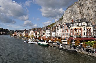
The Ardennes is a region with thick forests and rolling hills. The hills are usually between 350 and 400 meters high. In some areas, like the High Fens in southern Belgium, they are even higher, reaching over 694 meters. Fast rivers have carved steep valleys into the land. The Meuse River is the most famous.
There are some larger towns, like Verviers in Belgium and Charleville-Mézières in France, each with more than 50,000 people. But most places are smaller, with few towns having more than 10,000 people. Two exceptions in Belgium are Eupen and Bastogne.
The Eifel range in Germany is close to the Ardennes and shares the same geological history, but people usually think of them as two separate areas.
Geology
The Ardennes are part of an old mountain range formed long ago during the Hercynian orogeny. Similar places can be found in the Armorican Massif, the Massif Central, and the Vosges in France. Inside these mountains, there are valuable materials like coal, iron, zinc, and other metals hidden below the surface. This has shaped the landscape and history of Wallonia.
Recently, natural forces deep within the Earth, called a mantle plume, have pushed the ground higher in the Ardennes. This is most noticeable in the eastern part, where the Ardennes connects with a region called the Eifel. This geology has helped shape the economy, history, and landscape of Wallonia. Many important rock layers from long ago were first found in Wallonia, mostly in the Ardennes area.
Economy
The Ardennes covers parts of Belgium's Luxembourg Province, the south of Namur Province, and Liège Province, along with a small part of Hainaut Province. It also includes the northern part of the Grand Duchy of Luxembourg called "Éislek" and the French Ardennes department.
Long ago, people used charcoal from the Ardennes forests for fuel. Later, big steel factories grew up near coal mines, close to cities like Liège and Charleroi. Today, the land is used for growing crops and raising animals, and the forests give wood and wildlife. The beauty of the Ardennes makes it a popular place for tourists to visit and enjoy activities like hiking, cycling, and canoeing.
Etymology
The Ardennes gets its name from an old forest called Arduenna Silva. It was named during Roman times. The word Arduenna likely means "high" or "steep". Another part of the name might mean "fair" or "blessed". This suggests the area was once called the "forest of blessed heights".
This same name appears in many places in Britain, including a place called the Forest of Arden.
History
The modern Ardennes region is smaller than the forest that existed in Roman times.
An old French song from the 1100s called Quatre Fils Aymon mentions many rivers, villages, and places in Wallonia. In Dinant, there is a rock named Bayard after a magic horse from stories. This horse, named Bayard, is said to have jumped from the rock to the other side of the Meuse River.
The Ardennes has been important for many years because of its location. It was part of Luxembourg, which belonged to the Holy Roman Empire and changed hands many times. In 1793, France took over the area. After the Napoleonic Wars, the Congress of Vienna in 1815 returned most of the Ardennes to Luxembourg. But in 1839, Luxembourg gave part of the Ardennes to Belgium after Belgium became a country.
During World War I and World War II, the Ardennes was used by Germany to surprise attacks on France. The difficult terrain made it hard to defend, and German forces moved through it quickly in both wars. Many towns were damaged during these battles. After the wars, the Ardennes became a popular place for people to visit and enjoy outdoor activities.
Images
Related articles


This article is a child-friendly adaptation of the Wikipedia article on Ardennes, available under CC BY-SA 4.0.
Images from Wikimedia Commons. Tap any image to view credits and license.