 Safekipedia
Khangai Mountains
Adapted from Wikipedia · Adventurer experience
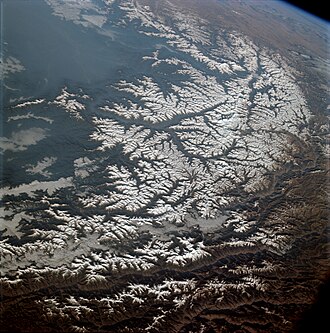
The Khangai Mountains form a range in central Mongolia, some 400 km (250 mi) west of Ulaanbaatar.
These mountains are an important part of Mongolia's landscape and beauty. They rise high above the plains, creating a varied environment. The Khangai Mountains are known for their rich wildlife and unique plants, making them a special place for nature lovers and scientists.
Name
Two provinces in Mongolia are named after the Khangai mountains: Arkhangai, meaning North Khangai, and Ovorkhangai, meaning South Khangai. The area where these two provinces meet has a mild climate and is important for Mongolian and nomadic cultures. The flat lands at the base of the eastern Khangai mountains include the Orkhon Valley World Heritage Site. Important old capitals, such as the Xiongnu capital Luut Khot, the Xianbei capital Ordo, and the Rouran capital Moomt, are believed to have been located there. Later, the Uyghur Khaganate built their capital Ordu-Baliq in this same region.
Features
The tallest mountain in the Khangai range is Otgontenger, which means "Youngest sky" and rises about 4,000 metres high. It is very important to the Mongols and they hold special ceremonies there. Ancient Turks also considered Otgontenger sacred.
Another important mountain is Suvraga Khairkhan, which is 3,117 metres tall and lies east of Tsetserleg.
The Khangai Mountains are the source of several rivers, including the Orkhon, Selenge, Ider, and Zavkhan, as well as lakes such as Orog and Böön Tsagaan. To the west, the mountains gradually change into the Great Lakes Depression.
This mountain region has milder weather in some places. Its winters are not as cold as in other parts of the country. Because of special weather patterns, the Khangai area can be about 10°C warmer than nearby regions, and even the highest peaks may be around 5°C warmer than the lower areas nearby.
Images
Related articles


This article is a child-friendly adaptation of the Wikipedia article on Khangai Mountains, available under CC BY-SA 4.0.
Images from Wikimedia Commons. Tap any image to view credits and license.