 Safekipedia
Wasatch Range
Adapted from Wikipedia · Adventurer experience
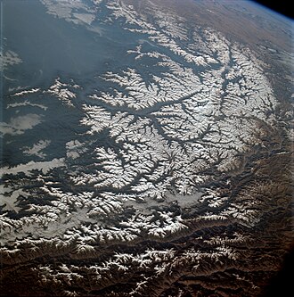
The Wasatch Range or Wasatch Mountains is a mountain range in the western United States. It runs about 160 miles (260 km) from the Utah–Idaho border south to central Utah. It is the western edge of the greater Rocky Mountains, and the eastern edge of the Great Basin region. The northern part of the Wasatch Range, called the Bear River Mountains, reaches just into Idaho and includes all of the Wasatch Range in that state.
In the language of the native Ute people, the word "wasatch" means "mountain pass" or "low pass over high range." The mountains may have been named after a Shoshoni leader whose name meant "blue heron." Different stories exist about the meaning of the name, showing how people have valued these mountains for a long time.
Overview
The Wasatch Range is a mountain range that stretches about 160 miles from the border of Utah and Idaho down to central Utah. It forms the western edge of the larger Rocky Mountains and the eastern edge of the Great Basin region. Many people in Utah live near the western side of these mountains, where rivers flow out. The area is called the Wasatch Front and has almost 3 million people. Salt Lake City is located between the Wasatch Range and the Great Salt Lake.
The highest point in the range is Mount Nebo, which stands at 11,928 feet. Other well-known peaks include Mount Timpanogos, Lone Peak, the Twin Peaks, and Mount Olympus. The Wasatch peaks have rugged scenery and receive lots of snow each year. This snow feeds rivers and supports many cities. The area is popular for skiing, with 11 ski areas from Sundance to Powder Mountain. The snow helped Salt Lake City host the 2002 Winter Olympics.
Geography and geology
The Wasatch Range formed when the Earth's plates moved and pushed the land up. Over millions of years, this made tall mountains and deep valleys. The mountains are still growing slowly as the land shifts.
Mount Nebo is the highest peak in the Wasatch Range. The mountains have many valleys and special places, including famous ski resorts like Alta, Brighton, Solitude, and Snowbird. These resorts are in a rugged area called the Cottonwoods. Other valleys, such as Ogden Valley and Heber Valley, have smaller towns and more ski areas. Several major highways, like I-80 and I-84, cross the range, making it easier for people to travel through the area.
Ecology
The Wasatch Range is part of a temperate coniferous forest area. You can find trees like Douglas fir, subalpine fir, Engelmann spruce, Colorado blue spruce, and quaking aspen here. Gambel oak grows on the foothills from near Brigham City south through the range. Ponderosa pine is mostly found only in special planted areas like Big Cottonwood Canyon and Logan Canyon.
Different types of sagebrush grow in drier parts of the range. Mountain big sagebrush is common, while basin big sagebrush used to grow in valley bottoms. In higher areas, you might find subalpine big sagebrush. Wyoming big sagebrush grows in the driest areas. All these sagebrush types help provide a home for greater sage grouse.
The Wasatch Range also has some special plants that grow only here. These include five-petal cliffbush, Sierra fumewort, and Utah angelica.
Recreation
The Wasatch Range has many fun activities for people to enjoy. You can go mountain biking and hiking on trails through beautiful canyons and valleys. There is also rock climbing and mountaineering on tall peaks made of limestone, granite, and quartzite.
In the winter, people enjoy ski touring, ski mountaineering, and snowshoeing. You can also fish in the alpine lakes and streams. The Wasatch Mountain Club holds regular events, and the Utah Native Plant Society leads walks to see wildflowers, especially in places like Albion Basin in Little Cottonwood Canyon.
The Salt Lake Valley is a big city area surrounded by the Wasatch Mountains.
Images
Related articles


This article is a child-friendly adaptation of the Wikipedia article on Wasatch Range, available under CC BY-SA 4.0.
Images from Wikimedia Commons. Tap any image to view credits and license.