 Safekipedia
Alaska Range
Adapted from Wikipedia · Discoverer experience
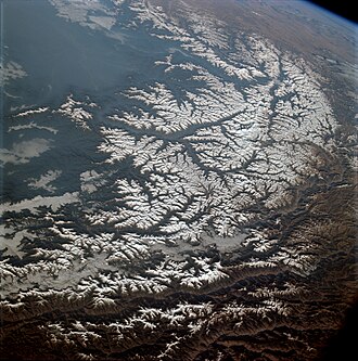
The Alaska Range is a tall, thin mountain chain that stretches for about 600 miles (970 kilometers) through the southcentral part of Alaska. It starts near Lake Clark on one end and reaches up to the White River in Canada’s Yukon Territory on the other. One of its most famous peaks is Denali, the tallest mountain in all of North America.
This mountain range is very high, standing among the greatest heights in the world. Only the Himalayas and the Andes have higher peaks than the Alaska Range. It is also part of a much larger chain of mountains called the American Cordillera, which runs down the western side of the U.S. state of Alaska.
Description
The Alaska Range stretches in an east-to-west curve, with its northernmost part in the middle. It trends southwest toward the Alaska Peninsula and the Aleutian Islands, and southeast into British Columbia and the Pacific Coast Ranges. These mountains block moist air from the Gulf of Alaska, creating some of the toughest weather in the world. The heavy snow feeds many large glaciers, like the Cantwell, Castner, Black Rapids, Susitna, Yanert, Muldrow, Eldridge, Ruth, Tokositna, and Kahiltna Glaciers. Four big rivers flow through the range, including the Delta and Nenana Rivers in the middle, and the Nabesna and Chisana Rivers further east.
The range is part of the Pacific Ring of Fire, and the Denali Fault along its southern edge causes many big earthquakes. Mount Spurr is a stratovolcano at the northeastern end of the Aleutian Volcanic Arc, with two main vents.
Some parts of the Alaska Range are protected in Wrangell-St. Elias National Park and Preserve, Denali National Park and Preserve, and Lake Clark National Park and Preserve. Several roads go through the range, like the George Parks Highway from Anchorage to Fairbanks via Windy Pass, the Richardson Highway from Valdez to Fairbanks via Isabel Pass, and the Tok Cut-Off from Gulkana Junction to Tok, Alaska via Mentasta Pass. The Alaska Pipeline runs close to the Richardson Highway. Part of the Alaska Highway sits on the northern slopes of the range’s eastern side.
History
The name "Alaska Range" was first used in 1869 by a naturalist named W. H. Dall. Before that, another name, "Tschigmit," was used by Constantin Grewingk in 1849. Early maps called different parts of the range the "Chigmit Mountains" and the "Beaver Mountains," but today the Chagmit Mountains are considered part of the Aleutian Range.
In the late 1800s and early 1900s, explorers began traveling through the Alaska Range. The first recorded trip was led by H. T. Allen in 1885. Other explorers followed, crossing different parts of the range and discovering new paths.
Major peaks
| Name | Elevation (ft/m) | |
|---|---|---|
| Denali | 20,310 | 6,190 |
| Mount Foraker | 17,400 | 5,300 |
| Mount Hunter | 14,573 | 4,442 |
| Mount Hayes | 13,832 | 4,216 |
| Mount Silverthrone | 13,218 | 4,029 |
| Mount Moffit | 13,020 | 3,970 |
| Mount Deborah | 12,339 | 3,761 |
| Mount Huntington | 12,240 | 3,730 |
| Mount Brooks | 11,890 | 3,620 |
| Mount Russell | 11,670 | 3,560 |
Subranges (from west to east)
The Alaska Range has several smaller mountain areas. From west to east, these include the Neacol Mountains, Revelation Mountains, Teocalli Mountains, Kichatna Mountains, Central Alaska Range/Denali Massif, Eastern Alaska Range/Hayes Range, Delta Mountains, Mentasta Mountains, and Nutzotin Mountains.
Documented wilderness traverses of Alaska Range
- Mentasta Lake to Kitchatna Mountains (1981): Scott Woolums, George Beilstein, Steve Eck, and Larry Coxen used skis for the first ever traverse, covering 375 miles (604 km) in 45 days.
- Canada to Lake Clark (1996): Roman Dial, Carl Tobin, and Paul Adkins made the first full-length traverse by mountain bike and packraft, traveling 775 miles (1,247 km) in 42 days.
- Tok to Lake Clark (1996): Kevin Armstrong, Doug Woody, and Jeff Ottmers completed the first foot traverse using snowshoes, walking, and a packraft, covering 620 miles (1,000 km) in 90 days.
- Lake Clark to Mentasta Lake (2016): Gavin McClurg achieved the first vol-biv (fly/camp) traverse using a paraglider and walking, covering 466 miles (750 km) in 37 days.
- Cantwell/Yakutat to Unimak Island (2020): Quoc Nguyen and Dan Binde traveled 2,500 miles (4,000 km) in 120 days using foot and packraft.
Images
Related articles


This article is a child-friendly adaptation of the Wikipedia article on Alaska Range, available under CC BY-SA 4.0.
Images from Wikimedia Commons. Tap any image to view credits and license.