 Safekipedia
Azad Kashmir
Adapted from Wikipedia · Discoverer experience
Azad Jammu and Kashmir, often called Azad Kashmir, is a region in the northern part of Pakistan. It is one of the areas that India and Pakistan have disagreed about since 1947. Azad Kashmir is next to the part of Kashmir controlled by India, with a special line called the Line of Control separating the two areas. To the north, it borders Gilgit–Baltistan, and to the south and west, it touches the Pakistani provinces of Punjab and Khyber Pakhtunkhwa.
The area covers about 13,297 square kilometers and is home to over 4 million people. Muzaffarabad is the capital city. Azad Kashmir has its own government, with a President as the head of state and a Prime Minister leading the government. There is also a Legislative Assembly and courts to help run the region. Although it has its own leaders, it still has some ties to the government of Pakistan.
In 2005, a big earthquake caused a lot of damage and sadly took many lives. Since then, efforts have been made to rebuild. The people of Azad Kashmir mainly work in farming, services, and tourism. The region also receives support from people living abroad, especially the British Mirpuri community. Today, Azad Kashmir has a high rate of children going to school and many people can read and write.
Name
Azad Kashmir, meaning "Free Kashmir," started as a pamphlet made by the Muslim Conference party in 1945. It showed that the Muslims in Jammu and Kashmir wanted to support the Muslim League's goal of creating a separate homeland called Pakistan. Later, in 1947, leaders asked the ruler to join Pakistan. After this, Sardar Ibrahim fled to Pakistan and began a rebellion in Poonch with help from Pakistan's leaders. Eventually, a temporary government for Azad Kashmir was formed in Lahore, with Sardar Ibrahim leading as prime minister.
History
Main articles: History of Azad Kashmir and 1947 Poonch rebellion
When India was divided into two countries in 1947, the ruler of Jammu and Kashmir wanted the state to stay independent. However, people in some areas wanted to join Pakistan.
Fighting began when local groups rose up against the ruler's forces. With help from nearby areas, they took control of several towns. This led to conflict between India and Pakistan, and a line was drawn to separate the areas each country controlled, called the Line of Control.
Later, Pakistan created a separate area called Azad Jammu and Kashmir, giving it its own government and leaders. Over time, this area gained more self-rule, though some important decisions are still made by Pakistan. The dispute over Kashmir continues to this day.
Geography
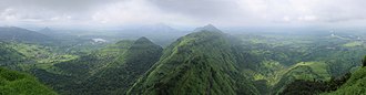
The northern part of Azad Jammu and Kashmir includes lower areas of the Himalayas, with Jamgarh Peak being one of the tall mountains. The highest peak in this area is Sarwali Peak, located in Neelum Valley.
The region gets rain in both winter and summer. Muzaffarabad and Pattan are some of the wettest places in Pakistan, with lots of rain, especially around Muzaffarabad. During summer, heavy rains and melting snow can cause floods in the Jhelum and Leepa rivers.
The southern parts of Azad Kashmir, like Bhimber, Mirpur, and Kotli, have very hot summers and cool winters, with rain mostly during monsoon time.
In the central and northern areas, summers are warm and winters are cold, sometimes with snow in December and January. Muzaffarabad and Pattan get a lot of rain but not snow. Like other parts, they also see floods during summer from heavy rains and melting snow.
Government and politics
See also: Azad Jammu and Kashmir Legislative Assembly, Prime Minister of Azad Kashmir, and Interim Constitution of Azad Jammu and Kashmir (1974)
Azad Jammu and Kashmir (AJK) is a region that has its own elected president, prime minister, legislative assembly, high court, and official flag. However, since a ceasefire in 1949 between Indian and Pakistani forces, Pakistan has controlled Azad Kashmir without fully making it part of the country.
Azad Kashmir has its own special council to handle its budget and taxes. This council includes members from both Azad Kashmir and Pakistan, with the prime minister of Pakistan as its leader. Each year on October 24, Azad Kashmir Day is celebrated to mark the creation of the government in 1947. Pakistan also marks Kashmir Solidarity Day on February 5 as a national holiday to show support for the people in the area.
Development project
According to the project report by the Asian Development Bank, the bank has set out development goals for Azad Kashmir in the areas of health, education, nutrition, and social development. The whole project is estimated to cost US$76 million. Germany, between 2006 and 2014, has also donated $38 million towards the AJK Health Infrastructure Programme.
Administrative divisions
See also: Districts of Azad Kashmir
The state is divided into three main areas, which are further split into ten districts.
| Division | District | Area (km2) | Population (2017 Census) | Headquarters |
|---|---|---|---|---|
| Mirpur | Mirpur | 1,010 | 456,200 | New Mirpur City |
| Kotli | 1,862 | 774,194 | Kotli | |
| Bhimber | 1,516 | 420,624 | Bhimber | |
| Muzaffarabad | Muzaffarabad | 1,642 | 650,370 | Muzaffarabad |
| Hattian | 854 | 230,529 | Hattian Bala | |
| Neelam Valley | 3,621 | 191,251 | Athmuqam | |
| Poonch | Poonch | 855 | 500,571 | Rawalakot |
| Haveli | 600 | 152,124 | Forward Kahuta | |
| Bagh | 768 | 371,919 | Bagh | |
| Sudhanoti | 569 | 297,584 | Palandri | |
| Total: 3 | 10 | 13,297 | 4,045,366 |
Demographics
Population
Azad Kashmir has about 4 million people, based on the 2017 census. Most people can read and write, and nearly all children go to school.
Religion
Almost all people in Azad Kashmir follow the Muslim faith. There are also small groups of Christian, Baháʼí, and Ahmadi communities, though these groups are quite small.
Ethnic groups
Most people in Azad Kashmir are not from the Kashmiri ethnic group. Instead, they share history and culture with people from nearby areas. The main groups include Gujjars, Sudhans, Jats, Rajputs, Mughals, Awans, Dhund, and some Kashmiri communities.
Languages
The main languages spoken in Azad Kashmir are Pahari-Pothwari, Gojri, and Kashmiri. The official language is Urdu, but many people speak other languages at home.
| Religious group | 1891 | 1901 | 1911 | 1921 | 1931 | 1941 | ||||||||
|---|---|---|---|---|---|---|---|---|---|---|---|---|---|---|
| Pop. | % | Pop. | % | Pop. | % | Pop. | % | Pop. | % | Pop. | % | |||
| Islam | 659,265 | 86.87% | 747,426 | 85.62% | 749,945 | 87.76% | 780,607 | 88.02% | 850,135 | 87.68% | 939,460 | 87.54% | ||
| Hinduism | 92,639 | 12.21% | 108,331 | 12.41% | 84,130 | 9.85% | 81,733 | 9.22% | 87,554 | 9.03% | 93,559 | 8.72% | ||
| Sikhism | 6,918 | 0.91% | 17,132 | 1.96% | 20,391 | 2.39% | 24,491 | 2.76% | 31,709 | 3.27% | 39,910 | 3.72% | ||
| Jainism | 64 | 0.01% | 0 | 0% | 8 | 0% | 6 | 0% | 11 | 0% | 0 | 0% | ||
| Christianity | 21 | 0% | 18 | 0% | 55 | 0.01% | 24 | 0% | 168 | 0.02% | 136 | 0.01% | ||
| Buddhism | 0 | 0% | 0 | 0% | 2 | 0% | 0 | 0% | 0 | 0% | 0 | 0% | ||
| Zoroastrianism | 0 | 0% | 0 | 0% | 0 | 0% | 0 | 0% | 1 | 0% | 0 | 0% | ||
| Tribal | 0 | 0% | —N/a | —N/a | —N/a | —N/a | —N/a | —N/a | 0 | 0% | 0 | 0% | ||
| Judaism | —N/a | —N/a | —N/a | —N/a | —N/a | —N/a | —N/a | —N/a | —N/a | —N/a | 0 | 0% | ||
| Others | 0 | 0% | 8 | 0% | 0 | 0% | 0 | 0% | 0 | 0% | 89 | 0.01% | ||
| Total population | 758,907 | 100% | 872,915 | 100% | 854,531 | 100% | 886,861 | 100% | 969,578 | 100% | 1,073,154 | 100% | ||
| Note1: 1891 & 1901 figures taken from census data by combining the total population of two districts (Bhimber and Muzaffarabad) and one Jagir (Poonch) in the Princely State of Jammu and Kashmir that ultimately would be administered by Pakistan, in the contemporary self-administrative territory of Azad Jammu and Kashmir. Note2: 1911–1941 figures taken from census data by combining the total population of two districts (Mirpur and Muzaffarabad) and one Jagir (Poonch) in the Princely State of Jammu and Kashmir that ultimately would be administered by Pakistan, in the contemporary self-administrative territory of Azad Jammu and Kashmir. | ||||||||||||||
Economy
Main article: Economy of Azad Kashmir
The economy of Azad Kashmir is mainly based on farming. People grow crops like barley, mangoes, millet, corn (maize), and wheat, and also raise cattle. In higher, less crowded areas, people earn money from forestry, corn, and raising animals. There are also minerals like marble near Mirpur and Muzaffarabad, as well as graphite at Mohriwali. Local workers make items such as carved wood, textiles, and carpets. There is also a market for arts and crafts, including special clothes, rugs, and silver items.
Besides farming, many people earn money by working in other countries and sending money back home. After the Mangla Dam was built in 1967, many people moved to the UK for work. Today, money sent home from the British Mirpuri community is very important to the economy. After the 2005 Kashmir earthquake, big projects began to rebuild the area.
Azad Kashmir has many beautiful places for tourists. The capital, Muzaffarabad, is near rivers and has spots like the Red Fort and Subri Lake. Other popular places include the Neelam Valley, Sudhanoti, Rawalakot, Bagh, the Leepa Valley, and New Mirpur City, each with its own special sights and lakes.
Education
Azad Kashmir has seen big improvements in education over the years. In 2004, about 62% of people could read and write. By 2018, this number grew to 76.6%, and by 2019 it was 79.8%. The latest data from 2020 to 2021 shows that nearly 91.34% of people can read and write. However, only a small part, about 2.2%, have finished university studies.
The area has several schools and colleges for students. There are special schools called cadet colleges in places like Palandri, Muzzaffarabad, and Mirpur. There are also medical schools for students who want to become doctors.
Sports
Football, cricket, and volleyball are very popular in Azad Kashmir. Many tournaments happen throughout the year, and special night-time games are held during the holy month of Ramazan.
Azad Kashmir has its own T20 tournament called the Kashmir Premier League, which began in 2021. New Mirpur City has a cricket stadium named Quaid-e-Azam Stadium, which is being improved by the Pakistan Cricket Board. Another stadium in Muzaffarabad can hold 8,000 people and has hosted games for young teams.
The area also has several football clubs, including:
- Pilot Football Club
- Youth Football Club
- Kashmir National FC
- Azad Super FC
Culture
Main article: Culture of Kashmir
Azad Kashmir shares much of its culture with the broader Kashmir region. This includes traditions, languages, and customs that have been passed down through generations. People in this area take pride in their heritage, celebrating festivals and maintaining ways of life that connect them to their history.
Tourism
Azad Kashmir is a beautiful place that attracts many visitors. It has many scenic spots, including mountains, rivers, and lakes. People enjoy hiking, camping, and exploring the natural wonders of the region. The area is known for its peaceful atmosphere and stunning views, making it a popular destination for tourists.
Notable people
Azad Kashmir has many well-known people who have made their mark in different fields. Some are politicians, like Nisaran Abbasi, Khalid Mahmood, and Mohammad Yasin. Others have served their country, such as Mujahida Hussain Bibi, Maqbool Hussain, and Saif Ali Janjua, who received brave awards.
There are also leaders who have held important positions, like Aziz Khan, who was the 11th Chairman Joint Chief of Staff Committee of the Pakistan Armed Forces, and Sardar Ibrahim Khan, the first and longest-serving President of Azad Kashmir. In sports, Zaman Khan plays cricket for the Pakistani national cricket team.
Images
Related articles


This article is a child-friendly adaptation of the Wikipedia article on Azad Kashmir, available under CC BY-SA 4.0.
Images from Wikimedia Commons. Tap any image to view credits and license.