 Safekipedia
Azimuth
Adapted from Wikipedia · Discoverer experience
An azimuth is a way to describe direction. It is the horizontal angle from a main direction, usually north, in a system that helps us understand positions on a sphere, like our Earth. To find an azimuth, we imagine a line from where we are to where we want to go. We then look at the angle this line makes with north when viewed from above.
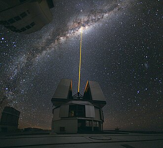
In astronomy, azimuth tells us the direction of stars or other objects in the sky from our viewpoint on Earth. It helps us understand where in the sky something appears, measured from north.
Azimuth is measured in degrees, from 0° to 360°, and is important in many fields. It is used in navigation to find our way, in astronomy to locate stars, in engineering and mapping to understand positions, and in many other areas where direction matters.
Etymology
The word azimuth comes from an old Arabic phrase, al-sumūt, which means "the directions." This word was used in astronomy and came into Latin from Arabic. The first time it appeared in English was in the 1390s in a book by Geoffrey Chaucer called A Treatise on the Astrolabe. Even earlier, around the 1270s, it showed up in Spanish in a book about astronomy, Libros del saber de astronomía, which was made for King Alfonso X of Castile.
In astronomy
Main article: Horizontal coordinate system
In the horizontal coordinate system, used in celestial navigation, azimuth is one of the two coordinates. The other is altitude, sometimes called elevation above the horizon. It is also used for satellite dish installation. In modern astronomy, azimuth is nearly always measured from the north.
In navigation
In land navigation, an azimuth is a horizontal angle measured clockwise from a north base line, also called a meridian. Today, true north is usually the reference point, with an azimuth of 0°. Moving clockwise around a circle, east has an azimuth of 90°, south 180°, and west 270°. Some navigation systems might use south as the starting point instead of north, but the reference direction must always be clearly defined.
Azimuths can also be described with either north or south as the starting point, and the angle can be measured clockwise or counterclockwise. For example, a direction might be described as "south, thirty degrees east," written as "S30°E." This means the direction is 30 degrees east from south, or 150 degrees clockwise from north. If a direction matches one of the main compass points, like east or west, a simpler phrase such as "due east" is used.
| Direction | Azimuth |
|---|---|
| N | 0° |
| NNE | 22.5° |
| NE | 45° |
| ENE | 67.5° |
| E | 90° |
| ESE | 112.5° |
| SE | 135° |
| SSE | 157.5° |
| Direction | Azimuth |
|---|---|
| S | 180° |
| SSW | 202.5° |
| SW | 225° |
| WSW | 247.5° |
| W | 270° |
| WNW | 292.5° |
| NW | 315° |
| NNW | 337.5° |
In geodesy
Main article: Inverse geodetic problem
See also: Earth section paths § Inverse problem, Vincenty's formulae § Inverse problem, and Geographical distance § Ellipsoidal-surface formulae
Imagine you are standing at one spot on Earth and want to know the direction to another spot. This direction is called an azimuth. We can think of the Earth as a perfect ball to get a good guess. For a more exact answer, we treat Earth as a slightly squashed ball, which gives two very close ways to measure this direction.
The first way, called normal-section azimuth, is the angle you would see if you looked straight up from the ground. The second way, called geodetic azimuth, is the angle between north and the shortest path on Earth’s surface to the other spot. For most everyday distances, these two angles are almost the same.
To find the normal-section azimuth, we use a special math formula that considers how much Earth is squashed. If you are right on the equator, the formula becomes even simpler. We can also use similar ideas to find the azimuth of the Sun or a star by using their positions in the sky instead of places on Earth.
In cartography
The cartographical azimuth or grid azimuth is a way to find directions on maps when we know the positions of two points on a flat surface. It uses a special math formula to figure out the angle between those points.
There are many types of azimuthal map projections. These special maps keep the true directions from a central point. Some navigation tools might use south as the starting point, but any direction can work as long as everyone agrees on what it is.
Comparison of some azimuthal projections centred on 90° N at the same scale, ordered by projection altitude in Earth radii (click for detail) |
Related coordinates
Right ascension
When we measure angles from the celestial equator instead of the horizon, these angles are called right ascension if we start from the Vernal Equinox, or hour angle if we start from the celestial meridian.
Polar coordinate
In math, the azimuth angle of a point in cylindrical coordinates or spherical coordinates is the angle you turn anticlockwise from the positive x-axis to the flat view of the vector on the xy-plane. A special case of this is the angle in polar coordinates, which is usually measured in radians instead of degrees.
Other uses
In the world of magnetic tape drives, the word azimuth describes the angle between the part that reads the tape and the tape itself.
When scientists study how we hear, they use azimuth to talk about the angle a sound makes compared to an imaginary line drawn through the middle of our head.
An azimuth thruster is a special kind of propeller used in shipbuilding that can turn sideways.
Images
Related articles


This article is a child-friendly adaptation of the Wikipedia article on Azimuth, available under CC BY-SA 4.0.
Images from Wikimedia Commons. Tap any image to view credits and license.