 Safekipedia
Joshua Tree National Park
Adapted from Wikipedia · Discoverer experience
Joshua Tree National Park is a beautiful US National Park in southeastern California. It sits between north-central Riverside County and part of southern San Bernardino County. The park is named after the special Joshua tree plant (Yucca brevifolia), which grows only in this area and nearby places. It is about 130 miles east of Los Angeles and close to cities like Indio, Palm Desert, and Palm Springs.
First protected as a national monument in 1936, Joshua Tree became a full national park in 1994 after the U.S. Congress passed the California Desert Protection Act. The park covers a huge area of 795,156 acres, which is a bit larger than the whole state of Rhode Island. Much of the park, about 429,690 acres, is kept as wild and natural designated wilderness.
Joshua Tree includes parts of two different deserts: the higher Mojave Desert and the lower Colorado Desert. These deserts are special ecosystems shaped mainly by their height above sea level, or elevation. The park’s southwest edge is lined with the Little San Bernardino Mountains.
History
The first people to live in the area that is now Joshua Tree National Park were the Pinto Culture, who were there long ago. After them came groups like the Serrano, Cahuilla, Chemehuevi, and Mojaves. These groups lived near water and used plants and animals for food and tools.
Later, Europeans arrived and began to explore the area. In the 1800s, settlers used the land for cattle, and miners searched for gold and other metals. In 1936, the area was protected as a national monument by President Franklin D. Roosevelt, and in 1994 it became Joshua Tree National Park.
Geography
Joshua Tree National Park has two main types of natural plants. Most of the park has creosote bush and desert shrubland, while higher areas on the west side have juniper and pinyon pine forests.
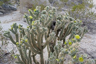
The Mojave Desert is home to the Joshua tree, which the park is named after. This desert has interesting rock formations and hills made of loose boulders, which are fun for climbing. The park has many Joshua trees, along with other plants like piñon pine and different types of oak and cactus. However, changes in the climate are making it harder for Joshua trees and other plants to grow. Some animals, like desert tortoises and certain birds, are also facing challenges.
The Colorado Desert, found at lower elevations in the park, has creosote bush, ocotillo, and various cacti. The Coachella Valley part of the park has sandy grasslands and desert dunes. Rare areas called oases have California fan palms, where many animals live.
Invasive plants like cheat grass and red brome can make wildfires worse. These plants grow thickly during wet times but stay dry and burn easily during dry periods, harming native plants. Fountain grass, brought to the park in the 1990s, also competes with native plants for water and nutrients.
The park has a hot desert climate, and recent changes have made it hotter and drier, leading to more wildfires.
Geology
The park's oldest rocks, Pinto Gneiss, are 1.7 billion years old. You can see them in the Cottonwood, Pinto, and Eagle Mountains. Later, between 250 to 75 million years ago, movements of Earth's plates pushed volcanic material to the surface, forming granites. This includes monzogranite, which is common in the Wonderland of Rocks and parts of the Pinto, Eagle, and Coxcomb Mountains.
Over time, erosion exposed harder rocks like gneiss and granite in higher areas, while softer rocks broke down into debris that filled valleys and basins. This debris moved by gravity and water, creating fan-shaped piles called alluvial fans at the ends of canyons and bajadas where fans joined together.
The shapes of the park's rock formations are due in part to groundwater, which slowly wore away the edges of stone blocks, and to flash floods, which removed soil and left piles of rounded boulders. These isolated rock mounds are called inselbergs.
The park has six mountain blocks. Five of them—the Little San Bernardino, Hexie, Pinto, Cottonwood, and Eagle—are part of the Transverse Ranges, which run east to west between the Eagle Mountains and the northern Channel Islands off Santa Barbara. The San Andreas Fault passes near the park, and related faults running through the park have caused earthquakes. The Coxcomb Mountains, the easternmost range, runs north to south and is part of the Basin and Range Province.
Recreation
Camping
There are nine places where you can set up camp in the park. You can also explore many hiking trails, some of which lead to the campgrounds. One trail, the California Riding and Hiking Trail, stretches for 35 miles on the west side of the park. From Keys View, you can see the Coachella Valley, the Salton Sea, the San Andreas Fault, the Santa Rosa Mountains, and the city of Palm Springs.
You can take nature walks to places like Hidden Valley. Longer trails lead to spots such as Contact Mine, Fortynine Palms Oasis, Lost Horse Mine, Lost Palms Oasis, Ryan Mountain, and Ruby Lee Mill Site. Some trails are closed because of damage done by visitors, including places important to Native American history, Rattlesnake Canyon, and Barker Dam. Officials think this problem is getting worse because of social media.
Climbing
Many people love to climb rocks in this park. It was first used by climbers when other famous places like Yosemite Valley were covered in snow during winter. Now, it is popular on its own. The park has thousands of climbing paths for all skill levels. The rocks are not very tall, usually less than 230 feet high, but they are rough and interesting to climb. You can often do several climbs in one day because the walks to the rocks are short and easy.
Some climbing paths are closed forever, and others are closed for short times to protect animals. Closed paths include Energy Crisis, the Schwarzenegger Wall, Zombie Woof Rock, the Maverick Boulder formation, Pictograph Boulder, Shindig, Lonely Stones Area #3, the Shipwreck formation, Indian Wave Boulders (except for Native Arete), and Wormholes.
Visitation statistics
The number of visitors grew a lot between 2013 and 2019. More people came to see the beautiful wildflowers that bloom in spring.
Wildlife
Over 250 kinds of birds live in or visit the park. You can see desert birds like the greater roadrunner, cactus wren, northern mockingbird, LeConte's thrasher, verdin, and Gambel's quail. About 78 of these birds build nests and raise their babies in the park. Many other birds stop by just to eat and rest, especially in winter, as the park is on a path that birds use when they fly along the Pacific coast. Some birds even come down from the mountains to avoid winter snow.
A list from 2006 mentioned 239 bird species in the park.
Astronomy
Joshua Tree is a great place for looking at the stars. The park has very dark night skies because it is far from city lights. In 2017, an group called the International Dark-Sky Association named Joshua Tree a Dark Sky Park.
Fauna and flora
Joshua Tree National Park is home to a rich variety of plants, fungi, and animals. Over 2,000 species have been recorded in the park. You can see many birds such as Gambel's quail and the greater roadrunner. Lizards, snakes, chipmunks, and California ground squirrels are also common.
Golden eagles, ravens, red-tailed hawks, burrowing owls, and turkey vultures are some of the birds that live in the park. At night, owls and bats are active, hunting for insects and small animals. The park is also home to mammals like the American badger, black-tailed jackrabbit, bobcat, coyote, desert bighorn sheep, gray fox, kangaroo rat, mountain lion, mule deer, and ringtail.
Reptiles such as rattlesnakes, kingsnakes, and the desert tortoise live in the park. The desert tortoise is especially adapted to dry conditions, getting most of its water from the plants it eats. Amphibians like the California tree frog and red-spotted toad can be found near water sources. Large insects and arachnids, including tarantulas, green darner dragonflies, and giant desert scorpions, also call Joshua Tree home.
Many animals in the park have special ways to survive the hot, dry climate. Smaller mammals and reptiles hide underground to stay cool. Birds can fly to water when they need it. During winter, many migratory birds visit the park, making it a great time for birdwatching.
Wilderness
Joshua Tree National Park covers 790,636 acres, and more than half of it is designated as wilderness. This means visitors must follow special rules to protect the natural environment. These rules include registering for overnight camping at certain spots, using a camp stove instead of open fires, and following "Leave No Trace" principles, which means taking all trash back with you.
Visitors can bring horses into the wilderness areas but need a special permit first. Bicycles are not allowed in these areas. Because the park is very remote, cell phone signals are usually very weak or nonexistent, so it’s best not to rely on them. The park offers amazing views, like from Keys View in the Little San Bernardino Mountains, where you can see far-off landmarks such as the Salton Sea, the Santa Rosa Mountains, and San Gorgonio Mountain.
Vandalism
In April 2015, an artist named André was fined for damaging a large rock in the park. He shared pictures of his "art" online. A hiker named Casey Schreiner and his followers helped the National Park Service find and report André's actions. Before facing consequences, André tried to stop people from talking about it using legal threats.
When the government did not fully fund important services in 2018–2019, there were very few park rangers to watch over the park. During this time, some visitors hurt the park by cutting down Joshua trees for fire wood, starting fires where they should not, driving where they should not, and painting rocks with spray paint. Park plant experts later found that one of the damaged Joshua trees had been cut down before this period.
Images
Related articles


This article is a child-friendly adaptation of the Wikipedia article on Joshua Tree National Park, available under CC BY-SA 4.0.
Images from Wikimedia Commons. Tap any image to view credits and license.