 Safekipedia
San Jacinto Mountains
Adapted from Wikipedia · Discoverer experience
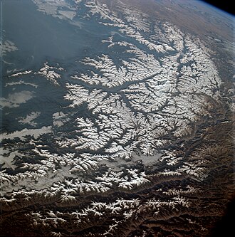
The San Jacinto Mountains (Mohave: Avii Hanupach) are a mountain range in Riverside County, located east of Los Angeles in southern California in the United States. These mountains are part of the beautiful landscape that many people enjoy for hiking and exploring.
The mountains are named for one of the first Black Friars, Saint Hyacinth (Spanish: San Jacinto), who is a popular patron in Latin America. This name connects the area to its rich history and cultural background.
The San Jacinto Mountains offer amazing views and are a great place for outdoor activities. They are an important part of the natural world and attract many visitors each year.
Geography
The San Jacinto Mountains stretch for about 30 miles (50 km) from the San Bernardino Mountains to the Santa Rosa Mountains. They are the northernmost part of the Peninsular Ranges, which extend 1,500 km (930 mi) from Southern California to the southern tip of the Baja California Peninsula. The highest point in the range is San Jacinto Peak, which stands at 3,302 meters (10,834 feet). The mountains also form part of the Great Basin Divide for the Salton Watershed to the east.
The Coachella Valley, home to cities like Palm Springs and Rancho Mirage, lies along the eastern side of the range. San Gorgonio Pass separates these mountains from Mount San Gorgonio to the north, while the western slope includes the community of Idyllwild. The range serves as the eastern boundary of the San Jacinto Valley, where Hemet is located, and marks the edge of the growing Inland Empire region and Greater Los Angeles area.
Much of the range is protected within the Santa Rosa and San Jacinto Mountains National Monument, established in 2000. Mount San Jacinto State Park lies along the side of San Jacinto Peak, and part of the eastern flank is within the Agua Caliente Indian Reservation. In 1990, the California Legislature formed the Coachella Valley Mountains Conservancy to help safeguard the surrounding mountains.
Geology
The San Jacinto Mountains are made of granitic rocks and are squeezed between two big faults: the San Jacinto fault on the west and the San Andreas fault on the east. The northern and eastern side of the range rises very quickly from sea level to over 10,000 feet in just a few miles, making it one of the steepest areas in North America. Because these faults are very active, they can cause major earthquakes, sometimes larger than magnitude 7. The last big earthquake in this area happened more than 200 years ago, so another one might happen in the future, though we can't predict when. During big earthquakes, rocks can sometimes slide down the mountains, which could affect nearby communities.
Climate
The San Jacinto Mountains have a special climate. Unlike the dry areas around them, the mountains get more rain. The western side gets between 15 to 32 inches of rain each year, while the eastern side gets less, about 6 inches. Most rain comes in the winter months from November to March, with some extra rain in the summer from July to September. Snow often falls above 4,000 feet in winter, and above 8,000 feet, snow can stay until June. Some shady spots near the top might even have snow all year long.
Flora and fauna
The San Jacinto Mountains are like an island in the sky, home to many plants and animals that cannot survive the very hot valleys below. The plants growing on the mountains change depending on how high you go. Near the bottom, only tough plants can live in the dry heat. As you climb higher, forests grow, including trees like California black oak and several kinds of pine. There is even a special area with over 150 giant sequoia trees that were planted by forest workers and are now thriving. Unfortunately, some trees have been lost recently due to insects and wildfires, like the Mountain Fire and the Cranston Fire. The mountains also have unique animals, such as the San Jacinto shieldback katydid.
Human use
The communities of Idyllwild-Pine Cove, Mountain Center, and Pinyon Pines are located in the San Jacinto Mountains. The indigenous Cahuilla people used these mountains for hunting and gathering, and to stay cool during the hot summer months.
Famous artists like Carl Eytel and Paul Grimm often painted the San Jacinto Mountains. Hollywood directors have also used the mountains as a backdrop for movies. One famous scene from the 1937 film Lost Horizon was filmed at Tahquitz Falls in Tahquitz Canyon.
Today, these mountains are a great place for outdoor activities. The Pacific Crest Trail passes through the range, and there is a popular walking path from the Palm Springs Aerial Tramway Mountain Station to the highest point. Above Idyllwild, you can find Tahquitz Peak and other spots for rock climbing.
Wilderness
The San Jacinto Wilderness was created in 1964 by the U.S. Congress with the help of the Wilderness Act. It covers two areas near Mount San Jacinto State Park and San Jacinto Peak. This large area of 32,168 acres is part of the San Bernardino National Forest and is cared for by the U.S. Forest Service.
Images
Related articles


This article is a child-friendly adaptation of the Wikipedia article on San Jacinto Mountains, available under CC BY-SA 4.0.
Images from Wikimedia Commons. Tap any image to view credits and license.