 Safekipedia
Oceania
Adapted from Wikipedia · Explorer experience
Oceania
Oceania is a beautiful region made up of many islands and the big land of Australia. It includes places like Australasia, Melanesia, Micronesia, and Polynesia. Oceania is the smallest continent and has about 46 million people living there.
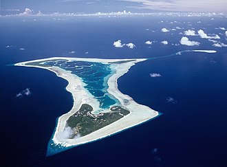
Islands and Lands
Oceania has many islands spread out in the ocean. Some of the biggest islands are New Guinea and mainland Australia. There are also many small islands, like the Cook Islands and Tokelau. These islands have unique plants and animals, such as the flightless kiwi bird in New Zealand.
People and Cultures
People have lived in Oceania for a very long time. In Australia, the first people were the Aboriginal Australians, and they have the longest-running art tradition in the world. Many cultures in Oceania have rich traditions, like the Māori people of New Zealand and the native Hawaiians. These cultures have special dances, songs, and stories that have been passed down for generations.
Nature and Animals
Oceania is home to many interesting animals. Australia has animals like kangaroos and koalas. New Zealand has unique birds like the tuatara, which looks like a lizard but is not a reptile. The islands also have beautiful coral reefs, like the Great Barrier Reef, which is one of the world’s largest.
Fun Facts
- Oceania includes the country of Australia, which is the only continent that is also a country.
- The Sydney Opera House in Australia is a famous building and a UNESCO World Heritage Site.
- Many movies, like The Lord of the Rings, were filmed in New Zealand because of its amazing landscapes.
- The people of Samoa have a special dance called the siva tau, which tells stories through movement.
Oceania is a wonderful place with diverse cultures, amazing landscapes, and unique wildlife. It’s a region full of history and natural beauty.
Images
Related articles


This article is a child-friendly adaptation of the Wikipedia article on Oceania, available under CC BY-SA 4.0.
Images from Wikimedia Commons. Tap any image to view credits and license.