 Safekipedia
Carpathian Mountains
Adapted from Wikipedia · Adventurer experience
The Carpathian Mountains or Carpathians are a large mountain range that stretches across Central Europe and Southeast Europe. It is about 1,500 kilometers long, making it the third-longest mountain range in Europe. The highest peaks are found in the Tatra Mountains, where some mountains rise over 2,600 meters tall.
These mountains run from Austria, through the Czech Republic, Slovakia, and Poland, and continue into Ukraine, Romania, and Serbia. The Carpathians are home to many wild animals, including brown bears, wolves, and lynxes. Romania, in particular, has many of these animals.
The area also contains many different plants, with over one-third of all European plant species living there. There are also many natural springs and waters. Romania has a lot of old-growth forests, some of the largest left in Europe, mostly in the Carpathians. However, these forests can be harmed by logging and deforestation.
Name
Further information: Carpi (people) § Name etymology
The Carpathian Mountains have many names, depending on the language. In Czech, Polish, and Slovak, they are called Karpaty. In Ukrainian, they are known as Карпати, and in Romanian, they are called Carpați. Other languages also have their own names for these mountains.
Long ago, different groups gave the mountains various names. Some old documents called the eastern part of the Carpathians the "Sarmatian Mountains" and the western part simply "Carpates." Stories from long ago also mention names like "Snowy Mountains" and "Hungarian Mountains." The exact origin of the name "Carpates" is not fully known.
Geography
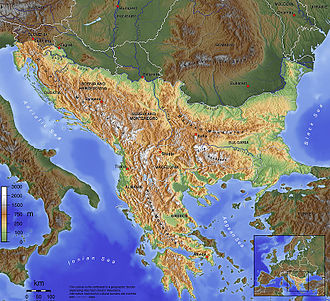
The Carpathian Mountains are a large mountain range that stretches over 1,500 km (930 mi) across Central and Southeast Europe. They start in Slovakia and southern Poland, curve around areas like Transcarpathia and Transylvania, and end near the Danube River in Romania.
These mountains are not a single, unbroken chain but are made up of several different groups. The highest peaks are in the Tatra Mountains, reaching over 2,600 m (8,500 ft). The Carpathians cover about 190,000 km2 (73,000 sq mi) and pass through several countries, including the Czech Republic, Austria, Slovakia, Poland, Ukraine, Romania, and Serbia. Unlike the Alps, the Carpathians have fewer very tall peaks and no large glaciers.
Geology
The Carpathian Mountains were formed long ago when Earth's surface changed a lot. This happened in the Mesozoic and Cenozoic time periods when big pieces of Earth's crust moved.
These mountains are made in a special way called a fold and thrust belt. They bend and push in different directions.
Today, this area is one of the most active places in Central Europe for small shakes and movements in the ground.
The outer part of these mountains is made from old sea bottom rocks. Inside the mountains, there are older rocks that were changed over time. About 30,000 years ago, the last big volcanic activity happened at Ciomadul.
The Carpathians started looking like they do today from the latest Miocene time onward. Some parts of their slopes have special deposits from old moving earth. Lots of iron, gold, and silver were found in the Western Carpathians.
Ecology
Main article: Carpathian montane conifer forests
The Carpathian Mountains have many plants and animals. In the lower areas, you can find forests with trees like oak and beech. Higher up, the trees change to spruce, and at the highest heights, there are no trees—just grasses and wildflowers.
The mountains are home to wildlife, including bears, wolves, lynxes, wildcats, special goats called chamois, bison, and golden eagles. These animals live in the forests and meadows of the Carpathians.
Divisions of the Carpathians
Main article: Divisions of the Carpathians
The Carpathian Mountains are grouped by country or region, but these groups change over time. Today, they are in Serbia, Romania, Ukraine, Poland, Slovakia, the Czech Republic, and Austria. Each country names and classifies parts of the Carpathians differently, making international comparisons tricky.
A large part of the western and northeastern Outer Eastern Carpathians is in Poland, Ukraine, and Slovakia and is called the Eastern Beskids. The border between the eastern and southern Carpathians runs through the Predeal Pass and the Prahova Valley.
The geological border between the Western and Eastern Carpathians runs from south to north between Michalovce, Bardejov, Nowy Sącz, and Tarnów. In Romania, the Carpathians are known as the Romanian Carpathians. Romanians often call only their part of the Eastern Carpathians the Eastern Carpathians, dividing them into three groups: Maramureș-Bukovinian Carpathians, Moldavian-Transylvanian Carpathians, and Curvature Carpathians.
In Ukraine, the Carpathians are called the Ukrainian Carpathians. Classifying the eastern parts of these mountains is complex because different traditions influence naming. Terms like Wooded Carpathians, Poloniny Mountains, and Eastern Beskids are used in various ways.
-
Beljanica region waterfall
-
Vrátna dolina, Slovakia
-
Maramureș. Mountains in the north of Romania and the west of Ukraine
-
Kežmarok in Slovakia
-
Gorals in the Polish Carpathians
-
Szczawnica in Poland, Pieniny, 1939
-
The Feast of the Assumption of Mary in the Polish Carpathians
Highest peaks
This is a list of the Carpathian peaks over 2,500 metres (8,200 ft), with their heights, geologic divisions, and locations.
Highest peaks by country
This is a list of the highest national peaks of the Carpathians, their heights, geologic divisions, and locations.
Cities and towns
The table and the list may contain some places near the Carpathians, not only in these mountains.
Smaller cities and towns:
- Piatra Neamț (Romania)
- Nowy Sącz (Poland)
- Suceava (Romania)
- Vršac (Serbia)
- Târgu Jiu (Romania)
- Drobeta-Turnu Severin (Romania)
- Reșița (Romania)
- Žilina (Slovakia)
- Bistrița (Romania)
- Zvolen (Slovakia)
- Deva (Romania)
- Zlín (Czech Republic)
- Hunedoara (Romania)
- Martin (Slovakia)
- Zalău (Romania)
- Przemyśl (Poland)
- Krosno (Poland)
- Sanok (Poland)
- Alba Iulia (Romania)
- Sfântu Gheorghe (Romania)
- Turda (Romania)
- Mediaș (Romania)
- Poprad (Slovakia)
- Spišská Nová Ves (Slovakia)
- Petroșani (Romania)
- Miercurea Ciuc (Romania)
- Făgăraș (Romania)
- Odorheiu Secuiesc (Romania)
- Boryslav (Ukraine)
- Jasło (Poland)
- Cieszyn (Poland)
- Nowy Targ (Poland)
- Żywiec (Poland)
- Zakopane (Poland)
- Petrila (Romania)
- Cugir (Romania)
- Târgu Neamț (Romania)
- Câmpulung Moldovenesc (Romania)
- Gheorgheni (Romania)
- Rakhiv (Ukraine)
- Vatra Dornei (Romania)
- Rabka-Zdrój (Poland)
- Bor (Serbia)
| Peak | Geologic divisions | Nation (Nations) | County (Counties) | Height (m) | Height (ft) |
|---|---|---|---|---|---|
| Gerlachovský štít | High Tatras | Slovakia | Prešov Region | 2,655 | 8,711 |
| Gerlachovská veža | 2,642 | 8,668 | |||
| Lomnický štít | 2,633 | 8,638 | |||
| Ľadový štít | 2,627 | 8,619 | |||
| Pyšný štít | 2,623 | 8,606 | |||
| Zadný Gerlach | 2,616 | 8,583 | |||
| Lavínový štít | 2,606 | 8,550 | |||
| Malý Ľadový štít | 2,602 | 8,537 | |||
| Kotlový štít | 2,601 | 8,533 | |||
| Lavínová veža | 2,600 | 8,500 | |||
| Malý Pyšný štít | 2,591 | 8,501 | |||
| Veľká Litvorová veža | 2,581 | 8,468 | |||
| Strapatá veža | 2,565 | 8,415 | |||
| Kežmarský štít | 2,556 | 8,386 | |||
| Vysoká | 2,547 | 8,356 | |||
| Moldoveanu | Făgăraș Mountains | Romania | Argeș | 2,544 | 8,346 |
| Negoiu | Sibiu | 2,535 | 8,317 | ||
| Viștea Mare | Brașov | 2,527 | 8,291 | ||
| Parângu Mare | Parâng Mountains | Alba, Gorj, Hunedoara | 2,519 | 8,264 | |
| Lespezi | Făgăraș Mountains | Sibiu | 2,517 | 8,258 | |
| Peleaga | Retezat Mountains | Hunedoara | 2,509 | 8,232 | |
| Păpușa | 2,508 | 8,228 | |||
| Vânătoarea lui Buteanu | Făgăraș Mountains | Argeș | 2,507 | 8,225 | |
| Omu (mountain) | Bucegi Mountains | Prahova, Brașov, Dâmbovița | 2,514 | 8,248 | |
| Cornul Călțunului | Făgăraș Mountains | Sibiu | 2,505 | 8,219 | |
| Ocolit (Bucura) | Bucegi Mountains | Prahova, Brașov, Dâmbovița | 2,503 | 8,212 | |
| Rysy | High Tatras | Poland, Slovakia | Lesser Poland Voivodeship, Prešov Region | 2,503 | 8,212 |
| Dara | Făgăraș Mountains | Romania | Sibiu | 2,500 | 8,200 |
| Peak | Geologic divisions | Nation (Nations) | County (Counties) | Height (m) | Height (ft) |
|---|---|---|---|---|---|
| Gerlachovský štít | High Tatras | Slovakia | Prešov Region | 2,655 | 8,711 |
| Moldoveanu | Făgăraș Mountains | Romania | Argeș | 2,544 | 8,346 |
| Rysy | High Tatras | Poland | Tatra County | 2,499 | 8,199 |
| Hoverla | Eastern Beskids (Chornohora) | Ukraine | Nadvirna Raion, Rakhiv Raion | 2,061 | 6,762 |
| Rtanj | Serbian Carpathians | Serbia | Zaječar District | 1,565 | 5,135 |
| Lysá hora | Moravian-Silesian Beskids | Czech Republic | Moravian-Silesian Region | 1,323 | 4,341 |
| Kékes | Mátra-Slanec Area (Mátra) | Hungary | Heves County | 1,014 | 3,327 |
| Hundsheimer Berg | Hundsheimer Berge | Austria | Niederösterreich | 481 | 1,578 |
Images
Related articles


This article is a child-friendly adaptation of the Wikipedia article on Carpathian Mountains, available under CC BY-SA 4.0.
Images from Wikimedia Commons. Tap any image to view credits and license.