 Safekipedia
Tehachapi Mountains
Adapted from Wikipedia · Adventurer experience
The Tehachapi Mountains are a mountain range in the Transverse Ranges of California in the Western United States. They stretch for about 40 miles across southern Kern County and northwestern Los Angeles County.
These mountains help separate the San Joaquin Valley from the Mojave Desert. The Tehachapi Mountains are part of a bigger group of ranges that shape the land and weather of this area. Their hills and valleys make lovely sights and give homes to many plants and animals.
Geography
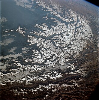
The Tehachapi Mountains are a range of hills and mountains in California. They separate the San Joaquin Valley to the northwest from the Mojave Desert to the southeast. These mountains reach heights between about 4,000 and 8,000 feet.
The range lies southeast of Bakersfield and the Central Valley, and west of Mojave and the Antelope Valley. It connects to the Southern Sierra Nevada on one end and to other mountain ranges on the other sides. A well-known road, Interstate 5, climbs steeply through this area and is called “The Grapevine.” This name comes from the grapevines that grow there. Important water projects and a famous winding railroad track also go through the Tehachapi Mountains.
Geology
The Tehachapi Mountains formed because of the Garlock Fault, a large crack in the Earth's surface. This fault runs from the San Andreas Fault to the Sierra Nevada Fault. The land on the other side of the fault moves to the left when you face it, which is different from most faults in California.
Natural history
The Tehachapi Mountains connect animals and plants between different mountain ranges and areas. There is not much building there, especially in the large Tejon Ranch area, so these natural connections are still strong.
The mountains have many different plants, including grasslands, oak woodlands, and forests. Some special plants grow only in this area. The mountains are also home to unique animals, such as certain salamanders and mice, as well as birds, deer, mountain lions, and even the California condor. These mountains mark the boundary between the dry Mojave Desert and areas with more rainfall, creating a mix of different climates and plant types.
History
The name Tehachapi may come from the Kawaiisu language, meaning "hard climb." The mountains have been home to several Indigenous groups, including the Kitanemuk, Kawaiisu, and Serrano people.
During Mexican rule, land grants were given in the Tehachapi area. These were later bought by Edward Beale and became Tejon Ranch. This large ranch stayed in his family until 1912. Today, Tejon Ranch is one of the biggest private properties in California, and there are plans for new developments in the Tehachapi Mountains.
Historic sites
The Tehachapi Mountains have many important historic spots. Oak Creek Pass was an old trail used by native people. In 1776, Francisco Garces was the first European to travel through it. Fort Tejon, built in 1854, is now a state historic park. Nearby was once a Chumash reservation. The area also had a big earthquake in 1857.
Other notable sites include the Monolith Cement Works, which made concrete for big projects like Hoover Dam. Old Tejon Pass was another old trail used by explorers in the 1700s and 1800s.
Peaks
Here are some of the tallest mountains in the Tehachapi Mountains:
- Double Mountain is 7,981 feet tall.
- Tehachapi Mountain is over 7,960 feet tall.
- Covington Mountain stands at 7,877 feet.
- Cummings Mountain is over 7,760 feet tall.
- Bear Mountain rises over 6,920 feet.
- Black Mountain is 5,686 feet tall.
- Grapevine Peak is 4,815 feet tall.
Images
Related articles


This article is a child-friendly adaptation of the Wikipedia article on Tehachapi Mountains, available under CC BY-SA 4.0.
Images from Wikimedia Commons. Tap any image to view credits and license.