 Safekipedia
Los Angeles County, California
Adapted from Wikipedia · Adventurer experience
Los Angeles County, often called LA County, is the most populous county in the United States, with about 9.7 million people living there. The county includes 88 cities and many other areas, covering 4,083 square miles. It is home to more than a quarter of all people living in California.
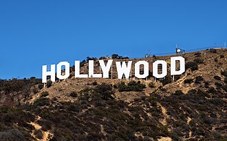
The main city in the county is Los Angeles, which is the second-most populous city in the United States. Los Angeles County is famous around the world as the home of the U.S. motion picture industry, making it a key place for movies and entertainment. The county is also one of the most ethnically diverse in the United States, with people from many different backgrounds living together.
History
Main articles: History of Los Angeles County, California and Ranchos of Los Angeles County
See also: Tovaangar; History of Los Angeles; Timeline of Los Angeles; History of Pasadena, California; History of the San Fernando Valley; Timeline of Long Beach, California; History of Santa Monica, California; and History of Santa Catalina Island"
Los Angeles County has been around since California became a state in 1850. It was bigger back then and included parts of what are now other counties. Over time, as more people moved in, parts of it were split off to create new counties.
Before the 1870s, the county was divided into different areas called townships. These included places like Azusa, El Monte, and the City of Los Angeles. Each township covered different parts of the land we know today.
Location
Los Angeles County is next to other areas. To the north is Kern County, to the east is San Bernardino County, to the southeast is Orange County, to the south is the Pacific Ocean, and to the west is Ventura County.
Geography
Los Angeles County is a big area in California. It has many kinds of land, like mountains, valleys, forests, lakes, rivers, and parts of the Mojave Desert. It also touches the Pacific Ocean.
Many people live in the south and southwest parts, especially near the Los Angeles Basin, San Fernando Valley, and San Gabriel Valley. The San Gabriel Mountains run through the county and have tall peaks like Mount San Antonio. The county also has islands like San Clemente Island and Santa Catalina Island off the coast.
The north has a desert climate, but most places have warm, dry weather. Rain usually comes in the winter, and mountains can get snow then.
Demographics
Main article: Demographics of Los Angeles County
Los Angeles County is very diverse with many different races and ethnicities. In the past, there were more White people in 1960 and more Black people in 1990. Today, most growth comes from Hispanic and Asian communities.
The county has many Asian Americans, including large groups of Burmese, Cambodian, Chinese, Filipino, Indonesian, Korean, Sri Lankan, Taiwanese, and Thai people. Some of the biggest Asian groups are Chinese, Filipino, and Korean.
Many different languages are spoken at home. Almost half of people speak only English, but many others speak Spanish, Tagalog, Chinese, Korean, Armenian, Arabic, or Hindi.
Los Angeles County has the largest Armenian population outside of Armenia and the largest Iranian population outside of Iran.
For the racial / ethnic profile of individual communities in Los Angeles County, see Demographics of Los Angeles County § Racial / Ethnic profile of places in Los Angeles County, California.
The county has many places of worship. There are over two thousand Christian churches, most of which are Catholic. There are also Jewish synagogues, Buddhist temples, Muslim mosques, Baháʼí Faith worship centers, Hindu temples, Tenrikyo churches, Shinto worship centers, and Sikh gurdwaras. The Roman Catholic Archdiocese of Los Angeles has about 5 million members, making it the largest diocese in the United States.
| Census | Pop. | %± | |
|---|---|---|---|
| 1850 | 3,530 | — | |
| 1860 | 11,333 | 221.0% | |
| 1870 | 15,309 | 35.1% | |
| 1880 | 33,381 | 118.0% | |
| 1890 | 101,454 | 203.9% | |
| 1900 | 170,298 | 67.9% | |
| 1910 | 504,131 | 196.0% | |
| 1920 | 936,455 | 85.8% | |
| 1930 | 2,208,492 | 135.8% | |
| 1940 | 2,785,643 | 26.1% | |
| 1950 | 4,151,687 | 49.0% | |
| 1960 | 6,038,771 | 45.5% | |
| 1970 | 7,041,980 | 16.6% | |
| 1980 | 7,477,503 | 6.2% | |
| 1990 | 8,863,164 | 18.5% | |
| 2000 | 9,519,338 | 7.4% | |
| 2010 | 9,818,605 | 3.1% | |
| 2020 | 10,014,009 | 2.0% | |
| 2025 (est.) | 9,694,934 | −3.2% | |
| U.S. Decennial Census 1790–1960 1900–1990 1990–2000 2010 2020 | |||
| Racial composition | 2020 | 2010 | 2000 | 1990 | 1980 | 1970 | 1960 | 1950 | 1940 |
|---|---|---|---|---|---|---|---|---|---|
| Hispanics | 48.0% | 47.7% | 44.5% | 37.8% | 27.6% | 14.9% | 11% | 5.8% | 2.2% |
| Non-Hispanic Whites | 25.6% | 27.8% | 31.1% | 40.8% | 52.8% | 70.9% | 79.3% | 87.9% | 93.3% |
| Asians | 14.7% | 13.5% | 11.9% | 11% | 5.6% | 2.9% | 1.9% | 1.3% | 1.9% |
| Blacks | 7.6% | 8.3% | 9.7% | 11.1% | 12.6% | 10.8% | 7.6% | 5% | 2.7% |
| Native Americans | 0.2% | 0.2% | 0.8% | 0.5% | 0.64% | 0.35% | 0.13% | - | - |
| Pacific Islanders | 0.2% | 0.2% | - | - | - | - | - | - | - |
| Multiracial Americans | 3.0% | 2.0% | - | - | - | - | - | - | - |
| Racial composition as of 2023 07 01 | |||||
|---|---|---|---|---|---|
| Total population | 9,663,345 | ||||
| Hispanics | 4,695,902 | 48.59% | |||
| Non-Hispanic Whites | 2,369,899 | 24.52% | |||
| Asians | 1,454,666 | 15.05% | |||
| Blacks | 709,583 | 7.34% | |||
| Native Americans | 16,890 | 0.17% | |||
| Pacific Islanders | 19,128 | 0.20% | |||
| Multiracial Americans | 336,840 | 3.49% | |||
Law, government, and politics
Government
Main article: Government of Los Angeles County
The Government of Los Angeles County is set up by the California Constitution, California law, and the Charter of the County of Los Angeles. Many jobs of the Government of California are done by local groups such as the Government of Los Angeles County.
The people of the county choose five leaders to be on the Los Angeles County Board of Supervisors. Each leader represents more than 2 million people. The board helps make rules, tells departments what to do, and makes decisions on important local matters.
The county’s leaders watch over a big budget and many workers. They have many departments that help people with different needs, like safety, health, and courts.
Politics
Main article: Politics of Los Angeles County
Los Angeles County has many areas that choose leaders for the U.S. House of Representatives, California State Senate, and California State Assembly.
Legal system
Further information: Los Angeles County Superior Court
Los Angeles County has important courts where people solve problems and settle legal matters. These courts are very busy because many people and famous people live there. Cases can be sent to higher courts for more review.
| Population and registered voters (Sept. 2025) | ||
|---|---|---|
| Total population | 9,757,179 | |
| Registered voters | 5,834,380 | 59.8% |
| Democratic | 2,988,634 | 51.2% |
| Republican | 1,098,884 | 18.8% |
| Democratic–Republican spread | +1,889,750 | +32.4% |
| American Independent | 200,191 | 3.4% |
| Libertarian | 48,197 | 0.8% |
| Peace and Freedom | 43,165 | 0.7% |
| Green | 28,444 | 0.5% |
| Unknown | 32,209 | 0.5% |
| Other | 45,961 | 0.8% |
| No party preference | 1,348,695 | 23.1% |
Crime
Sorry, this section talks about serious and sensitive topics that are not suitable for young readers. We’ve skipped it to keep things safe and appropriate.
Ecology
Los Angeles County has lots of wildlife! It has over 500 kinds of birds, making it a great place to spot them. The warm weather lets many animals live here, like tropical birds and parrots that eat fruit from trees such as dates, figs, and loquats.
The county has many different landscapes, from mountains to deserts to oceans. This means you might see animals like desert bighorn sheep and green sea turtles in the same day! There are also many insects, mammals, and reptiles, such as bobcats, gray foxes, and mule deer. Seeing these animals helps scientists learn about the environment, and you can help by reporting what you see using the iNaturalist app.
Economy
See also: Los Angeles Chamber of Commerce
Los Angeles County is well-known for its entertainment and digital media industry. All five major film studios—Paramount Pictures, Sony Pictures, Warner Bros., Universal Pictures, and Walt Disney Studios—are located here. The county has many other important industries, such as international trade helped by the Port of Los Angeles and the Port of Long Beach, music recording, aerospace, fashion, and professional services like law, medicine, and engineering. There are many jobs in high-tech and manufacturing in the area. After the COVID-19 pandemic, some businesses moved away from Downtown Los Angeles, but the city is growing as a cultural center with many buildings designed by famous architect Frank Gehry.
The following major companies have headquarters in Los Angeles County:
Education
The Los Angeles County Office of Education helps school districts. It runs two special schools: the International Polytechnic High School and Los Angeles County High School for the Arts. Many private schools are in the county, especially those run by the Roman Catholic Archdiocese. The largest public school system is the Los Angeles Unified School District, which serves the city of Los Angeles and nearby areas.
Colleges
Universities
K–12 schools
Main article: List of school districts in Los Angeles County, California
See also: List of schools in the Roman Catholic Archdiocese of Los Angeles
Sites of interest
Los Angeles County has many fun places to see. The most popular park is Griffith Park, owned by the city of Los Angeles. You can also watch the yearly Rose Parade in Pasadena and visit the Los Angeles County Fair in Pomona. Other cool spots include the Los Angeles County Museum of Art, the Los Angeles Zoo, and the Natural History Museum of Los Angeles County.
The area has famous beaches like Venice Beach and Santa Monica's pier, which has a big Ferris wheel. In the mountains, you can go to Vasquez Rocks Natural Area Park, where old Western movies were made, and the Mount Wilson Observatory for looking at the stars.
Museums
- Academy Museum of Motion Pictures
- Armory Center for the Arts, Pasadena, California
- Battleship USS Iowa, Los Angeles Waterfront in San Pedro
- SS Lane Victory, Los Angeles Waterfront in San Pedro, just south of the USS Iowa
- California African American Museum
- California Science Center, Los Angeles (formerly the Museum of Science and Industry)
- The Broad
- Hammer Museum
- Huntington Library, San Marino
- Long Beach Museum of Art in the historic Elizabeth Milbank Anderson residence
- Los Angeles Children's Museum
- Los Angeles County Fire Museum, in Bellflower
- Los Angeles County Museum of Art, Mid-City, Los Angeles
- Lucas Museum of Narrative Art
- Museum of Contemporary Art, Downtown Los Angeles (founded in 1950); The Geffen Contemporary at MOCA, Downtown Los Angeles (founded in 1980)
- Museum of Jurassic Technology, Culver City
- Museum of Latin American Art in Long Beach
- Museum of Neon Art
- Museum of the American West (Gene Autry Museum), in Griffith Park
- Museum of Tolerance
- Natural History Museum of Los Angeles County
- Pasadena Museum of California Art, in Pasadena
- J. Paul Getty Center, Brentwood (Ancient Roman, Greek, and European Renaissance Art)
- J. Paul Getty Villa, Pacific Palisades, Getty's original house
- George C. Page Museum at La Brea Tar Pits
- Santa Monica Museum of Art, Santa Monica (Contemporary art)
- Norton Simon Museum, Pasadena (19th- and early 20th-century art)
- Skirball Cultural Center, Los Angeles
- Southwest Museum
Entertainment
- Los Angeles Memorial Coliseum
- Descanso Gardens
- Dodger Stadium
- Exposition Park
- Farmers Market
- The Forum
- Griffith Park
- Griffith Observatory
- Huntington Botanical Gardens
- La Brea Tar Pits
- Music Center
- Olvera Street
- Crypto.com Arena
- SoFi Stadium
- South Coast Botanic Garden
- Third Street Promenade
- Venice Beach
- Los Angeles Zoo
- Santa Fe Dam Recreation Area
Music venues
- California Plaza, comprising One California Plaza and Two California Plaza
- Cerritos Center for the Performing Arts
- Crypto.com Arena
- The Forum
- Walt Disney Concert Hall
- Greek Theatre
- House of Blues Sunset Strip
- Pantages Theatre
- Hollywood Bowl
- Hollywood Palladium
- John Anson Ford Amphitheatre
- The Orpheum Theatre
- The Roxy Theatre
- Royce Hall (UCLA)
- The Music Box
- El Rey Theatre
- The Troubadour
- The Wiltern
- Whisky a Go Go
Amusement parks
- Universal Studios Hollywood
- Raging Waters, San Dimas
- Six Flags Magic Mountain
- Six Flags Hurricane Harbor
- Pacific Park
Other attractions
Other areas
- Ridge Route
- Angeles National Forest
- Mount Wilson Observatory
- Malibu Creek State Park
- Vasquez Rocks Natural Area Park
- Plant 42's Blackbird Airpark and Heritage Airpark
- Antelope Valley California Poppy Reserve
- Cortes Bank
- Santa Catalina Island
- Mojave Desert
- Saddleback Butte State Park
- Antelope Valley Indian Museum State Historic Park
- Arthur B. Ripley Desert Woodland State Park
Transportation
Main article: Transportation in Los Angeles
Los Angeles County has many ways to get around, including highways, airports, trains, and ports.
Major highways
Los Angeles County has many important highways that help people travel within the county and to other places. Some of the main highways include:
- I-5
- I-10
- I-105
- I-110 / SR 110 (Harbor Freeway / Arroyo Seco Parkway)
- I-210 / SR 210 (Foothill Freeway)
- I-405
- I-605
- I-710 / SR 710 – SR 710 is unsigned
- US 101
- SR 1 (Pacific Coast Highway)
- SR 2
- SR 14 – former US 6
- SR 18
- SR 19 / SR 164
- SR 22
- SR 23
- SR 27
- SR 39
- SR 47
- SR 57
- SR 60 – former US 60
- SR 66 (Foothill Boulevard) – former US 66
- SR 71
- SR 72
- SR 90
- SR 91 – former US 91
- SR 103
- SR 107
- SR 118
- SR 126
- SR 134
- SR 138
- SR 170
- SR 213
Air
Los Angeles International Airport (LAX), located in the Westchester district, is the main airport for the county and the Greater Los Angeles Area. LAX is run by Los Angeles World Airports (LAWA), an agency of the City of Los Angeles.
Other important airports in Los Angeles County include:
- Long Beach Municipal Airport run by the City of Long Beach.
- Hollywood Burbank Airport in Burbank, run by the Burbank-Glendale-Pasadena Airport Authority.
The county also has several general aviation airports, including:
- County-run airports (Department of Public Works, Aviation Division)
- Compton/Woodley Airport in Compton.
- San Gabriel Valley Airport in El Monte.
- Brackett Field in La Verne.
- Whiteman Airport in Pacoima.
- General William J. Fox Airfield in Lancaster.
- City-run airports
- Van Nuys Airport in Van Nuys, also run by LAWA. Van Nuys Airport has a lot of executive jet traffic.
- LA/Palmdale Regional Airport in Palmdale. This airport shares space with Air Force Plant 42.
- Santa Monica Airport in Santa Monica, which has major executive jet traffic.
- Hawthorne Municipal Airport, also known as Jack Northrop Field, in Hawthorne.
- Zamperini Field in Torrance.
The U.S. Air Force runs three airports in Los Angeles County:
- Part of Edwards Air Force Base, located at the northern edge of the county.
- Air Force Plant 42 in Palmdale, which shares runways with LA/Palmdale Regional.
- The non-flying Los Angeles Air Force Base in El Segundo.
Rail
Los Angeles is a big center for freight railroads, especially because of the large amount of goods moving in and out of the county's seaports. The ports are connected to downtown rail yards and to the main lines of Union Pacific and Burlington Northern Santa Fe through a special freight rail corridor called the Alameda Corridor.
Passenger rail service in the county is provided by Amtrak, Los Angeles Metro Rail and Metrolink.
Amtrak has several intercity services at Union Station in Los Angeles:
- The Pacific Surfliner to Santa Barbara, San Luis Obispo, and San Diego.
- The Coast Starlight to San Francisco Bay Area, Portland and Seattle.
- The Southwest Chief to Albuquerque, Kansas City and Chicago.
- The Sunset Limited to Tucson, Houston and New Orleans.
Union Station is also the main hub for Metrolink commuter rail, which serves much of the Greater Los Angeles Area.
The Los Angeles County Metropolitan Transportation Authority (Metro) provides light rail, subway (heavy rail), and long-distance bus service. Other smaller regional transit agencies serve specific parts of Los Angeles County.
Sea
The county's two main seaports are the Port of Los Angeles and the Port of Long Beach. Together, they handle over a quarter of all container traffic entering the United States, making them the largest and most important port complex in the country, and the third-largest port in the world by shipping volume.
The Port of Los Angeles is the largest cruise ship center on the West Coast, handling more than 1 million passengers each year.
The Port of Long Beach is home to the Sea Launch program, which uses a floating platform to launch payloads into orbits that are hard to reach from land.
Catalina Express ferries connect Catalina Island's city of Avalon to the mainland at San Pedro and Long Beach, as well as Dana Point in Orange County.
Water
Los Angeles County gets water from more than 200 water districts or agencies. Because of droughts in California, it can sometimes be difficult to have enough water for everyone.
Communities
For the racial / ethnic profile of individual communities in Los Angeles County, see Demographics of Los Angeles County § Racial / Ethnic profile of places in Los Angeles County, California.
Cities
Main article: List of cities in Los Angeles County, California
Los Angeles County has 88 cities. The biggest cities are listed here:
Unincorporated areas
Census-designated places
- Acton
- Agua Dulce
- Alondra Park
- Altadena
- Avocado Heights
- Castaic
- Charter Oak
- Citrus
- Del Aire
- Desert View Highlands
- East Los Angeles
- East Pasadena
- East Rancho Dominguez
- East San Gabriel
- East Whittier
- Elizabeth Lake
- Florence-Graham
- Green Valley
- Hacienda Heights
- Hasley Canyon
- La Crescenta-Montrose
- Ladera Heights
- Lake Hughes
- Lake Los Angeles
- Lennox
- Leona Valley
- Littlerock
- Marina del Rey
- Mayflower Village
- North El Monte
- Pepperdine University
- Quartz Hill
- Rose Hills
- Rowland Heights
- San Pasqual
- South Monrovia Island
- South San Gabriel
- South San Jose Hills
- South Whittier
- Stevenson Ranch
- Sun Village
- Topanga
- Val Verde
- Valinda
- View Park-Windsor Hills
- Vincent
- Walnut Park
- West Athens
- West Carson
- West Rancho Dominguez
- West Puente Valley
- West Whittier-Los Nietos
- Westmont
- Willowbrook
Other unincorporated communities
- Agoura
- Alla
- Alpine
- Andrade Corner
- Antelope Acres
- Antelope Center
- Athens
- Bassett
- Big Pines
- Castaic Junction
- City Terrace
- Cornell
- Del Sur
- Del Valle
- Firestone Park
- Florence
- Gorman
- Hillgrove
- Hi Vista
- Juniper Hills
- Kagel Canyon
- Kinneloa Mesa
- Largo Vista
- Llano
- Los Nietos
- Malibu Vista
- Monte Nido
- Neenach
- Ninetynine Oaks
- Pearblossom
- Rancho Dominguez
- Sandberg
- Sand Canyon
- Seminole Hot Springs
- Three Points
- Two Harbors
- Universal City
- Valyermo
- West Whitter
Proposed communities
- Centennial (planned for 70,000).
See: Los Angeles Almanac MAP: Unincorporated Areas and Communities of Los Angeles County
See also: List of districts and neighborhoods of Los Angeles
| City | Population |
|---|---|
| Los Angeles | |
| Long Beach | |
| Santa Clarita | |
| Glendale | |
| Lancaster | |
| Palmdale | |
| Pomona | |
| Torrance | |
| Pasadena | |
| Downey | |
| West Covina | |
| El Monte | |
| Burbank | |
| Inglewood |
Images
Related articles


This article is a child-friendly adaptation of the Wikipedia article on Los Angeles County, California, available under CC BY-SA 4.0.
Images from Wikimedia Commons. Tap any image to view credits and license.